| Parish/District | North Rauceby/North Kesteven |
| Location | On a green at the road junction south east of the church. |
| Category | Village cross (restored) |
| National Grid Ref | TF 02208 46390 |
| Designation | Scheduled / Listed II |
| Stone Type | Limestone |
| Refs | AP Survey, 1 Dec 1993; Davies, D S, 1913, Lincs N & Q, Vol XII No.5, p.145; Trollope, Sleaford, etc, p.286; Whites 1856 Directory, p.454; Assoc Archit Soc Reports & Papers, 7, 1863-4, 21-5 |
| Visits | AP: 1 Dec 1993 | DS/HH: 24 Aug 2012 |
There is a restored cross on a small triangular green at the junction of Main Street, Tom Lane and Church Lane, c. 100m south east of St Peter’s church.
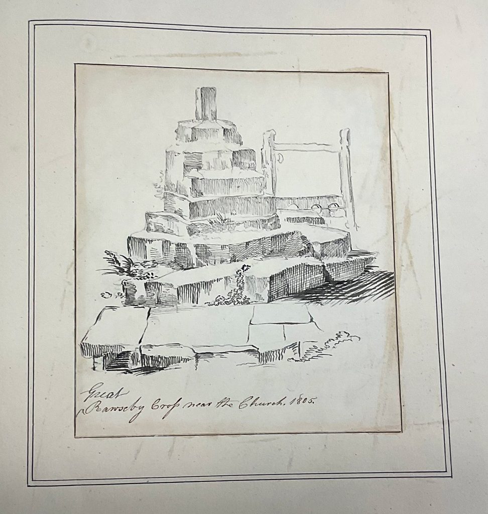
C J Nattes drew a cross at Great (North) Rauceby in 1805 (see below). He shows a stump of shaft set in a hexagonal socket stone, mounted on six steps. The village stocks are pictured nearby, suggesting this is the village cross. The socket stone drawn by Nattes does not look like the socket stone of the present restored cross, and it is possible the whole structure was replaced in the process of ‘restoration’.
Confusingly, the Lincs HER suggests that the cross base was moved from the churchyard and restored on the green in 1863/64 although the source for this information and date is not clear. Perhaps the cross, already ruinous in 1805, was dismantled and the cross base placed in the churchyard pro tem ? However, White’s 1856 Directory states: ’In the village is the pedestal, and part of the shaft of an ancient cross’ which suggests the unrestored cross remained on the green.
A visit by the Arch Soc of Lincoln in 1863 records (p.25) ‘Near the church has long stood the base of a village cross, but lately that base has again been supplied with a graceful shaft and terminal, and now forms a charming feature close to the garden gate of the vicarage and on the way to the church.’ Trollope, writing in 1872, confirms: ‘At the corner of the vicarage garden . . ., has long stood the base of a village cross. This has of late years been supplied with a graceful shaft and finial . . .’ Interestingly, the 1888 O.S. 25” map shows the cross on its green as: ‘Cross on Site of Cross’.
Thus, it seems possible that North Rauceby village cross is entirely restored, but is on the site of the original cross, as drawn by Nattes (and as recorded on the O.S. map).
AP, when compiling the scheduling document, clearly thought it was the village cross on, or close to, its original location. The entry in White’s directory adds ‘. . . on the green a market was formerly held‘ – although no market charter is recorded for North Rauceby.
The cross as it now stands comprises two restored steps a socket stone set on a chamfered plinth, and a modern tapering octagonal shaft with a tabernacle type head.
The lower step, now mostly buried, is c. 2.15m square and the upper step c. 1.52m square. On the upper step stands a (probably modern) socket-stone on a plinth which is 0.92m square in section and 0.21m high with slightly chamfered upper corners; the socket stone is 0.78m square in section at the base, rising in octagonal section through moulded and chamfered corners to a height of 0.72m. The shaft is of tapering octagonal section and of one piece with the knop. The head takes the form of a gabled tabernacle topped by a crucifix with floriate decoration. The shaft, knop and head are all modern, and the cross bases also probably modern, dating from the 19th century restoration. The full height of the cross is about 4.5m.